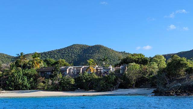
In 1977, Laurance Rockefeller separated the “Premises”, the land that Caneel Bay Plantation sat on, from the “Improvements”, the structures and operation of the resort. 150 acres of the “Premises” were deeded to the Rockefeller family land trust, Jackson Hole Preserve, Inc. (JHPI); the structures or “Improvements” on that land were kept by Caneel Bay, Inc. with a future Deed that would revert the “Improvements” to Jackson Hole Preserve on September 30th, 2023
Hurricanes
What is currently happening with Caneel Bay?
What is the fundamental issue between the U.S. Government, NPS and EHI/CBI Acquisitions? The following 3 Part Article will attempt to delve into some of the key components of the 1983 Indenture, scripted by Laurance Rockefeller in 1983, that outlines the Retained Use Estate (RUE) leasehold within that document which is central to both parties’ pending Motions for Summary Judgement. The author will do her best to explain the facts in detailing what has already transpired and what the future may hold.
Hurricane Tammy: Latest Updates
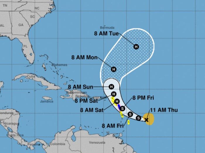
Good morning. Tropical Storm Tammy has been upgraded to a Category 1 Hurricane as of Friday morning. Peak winds are now estimated to be 75mph.
It is going to generate some less-than-ideal weather in St. John this weekend, but the good news is, it is on a path that is moving away from us.
Below is an updated report from the National Hurricane Center indicating the various warnings and watches in effect for different islands,
Health and Environmental Impacts as the Annual Saharan Dust Returns to the Caribbean

Good morning, good morning!
The annual arrival of ethereal sunsets and a light, hazy fog is coming to the Caribbean a little early this year. Deriving from the Saharan desert in Northern Africa, a massive plume of dust is expected to bring its haze within the next few weeks. Typically not seen until May or June, the Saharan Air Layer, or SAL, will be making its first appearance on the northernmost tip of South America by today. By next week, small clouds of dust and sand will begin to coat the Lesser Antilles.
Read moreHealth and Environmental Impacts as the Annual Saharan Dust Returns to the Caribbean
Curfew lifted, ports remain closed
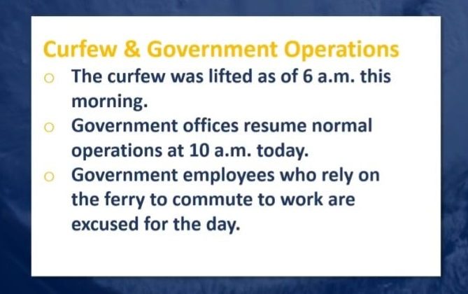
Good morning! As of 6:00 am, the roads are clear and the curfew has been lifted. The ports are closed until further notice; we will let you know when they re-open. The airports remain open.
According to the Governor, the ocean is not safe for swimming today due to remaining swells, but there are many other enjoyable ways to spend your day! Help support our local economy with some shopping, go for a hike on one of our many trails, or learn about some of the fascinating and important St. Johnian history at Annaberg Sugar Plantation.

Storm-related ferry and port closure this morning
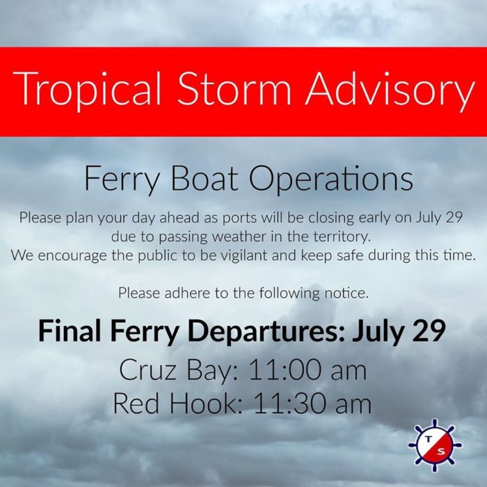
Good morning! A tropical storm warning is in effect for St. John. We will bring you the latest update regarding the storm shortly after the Governor’s press conference at 10:00 am. In the meantime, if you are leaving the island today, the last passenger ferries to Red Hook and Crowne Bay will depart at 11:00 am before the ports shut down entirely for the day. If anything changes we will let you know!
New Hyper Local Website Launches

Hey everyone, happy Monday!
Today we wanted to tell you about a new site that just launched yesterday. It’s called Life on Our Rock and we think it’s going to be very cool.
The site’s the brainchild of Active St. John. Our friends over there were sick and tired of wrong information being spread around the island when an emergency event was occurring. For example, a few years back someone was sitting at the bar and said a huge storm was coming. Word quickly spread and people started to panic. Well it turned out that no storm was really coming and therefore people unnecessarily panicked. The goal of this site is to prevent things like that from happening by reporting accurate, real time information.
Active reached out to us for help, so we’ve been working with them for a bit to make the site work. We think it turned out pretty well. See for yourself here: www.LifeonOurRock.com
As you will see, the site includes a variety of important links such as VI Alerts – so you can view any warnings or emergency information – Tropical Weather – so you can see the most up-to-date information if a storm is in fact coming – and Port Links – so you can be made aware if the ports close or are about to close due to an impending storm.
And because Active is just as obsessed as we are with the fact that the new ferries still aren’t running and that the “fedral” and “emergency” road repairs on Centerline still haven’t been completed, there’s a boatload of information on that too including a plethora of articles from multiples sources on each dating back to 2009.
Again, it just launched yesterday but we have a feeling it’s going to be very cool. Be sure to check it out: www.LifeonOurRock.com
Tropical Storm Watch in Effect
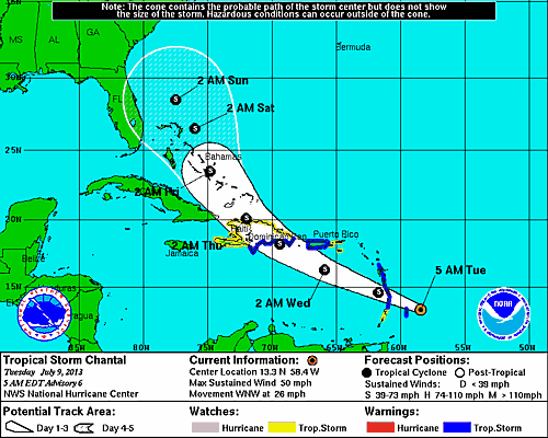
Tropical Storm Chantal is churning up the Caribbean Sea and moving quickly, but it looks like St. John will be spared a direct hit.
As of this morning (6 a.m.), the storm was about 520 southeast of St. Croix with maximum winds of 50 mph. According to the National Weather Service, Tropical Storm Chantal is expected to move west-northwest over the next 24-36 hours. Rain and squalls will begin affecting St. John and the surrounding areas this evening and into Wednesday.
The good news if that hurricane conditions are very unlikely to occur with this storm. The bad news is that the storm is expected to strengthen a bit as it moves closer. That means the threat of sustained high winds will increase as the storms nears, although they are expected to stay under tropical storm force. A storm surge is not expected, but tides on the south and east coasts are expected to be one to two feel about normal.
What does this mean for St. John? Well, the system has the potential to bring flooding rains to the area and high wind gusts. That means it’s time to bring your pets inside, secure your boats and put away any of those items outside that you would really miss should they blow away. For the tourists on the island, it means you should probably hunker down at the nearest bar, preferably with a Bushwacker in hand.
In all seriousness my tourists friends and locals alike, it seems as if this is going to be a windy, rain event. For the latest on Tropical Storm Chantel, please check out any of these websites:
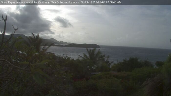
If you’d like to see live conditions of what’s happening in St. John, please check out Great Expectation’s webcam, which provides a great view of the south shore. You can find that webcam here.
This image was captured this morning:
Forecasters see calmer hurricane season
All clear for Easter.
The chance of a hurricane blowing across St. John later this year is markedly less than usual, according to scientists at Colorado State University.
The two men, Philip Klotzbach and William Gray, are nationally known for their hurricane outlooks.
For the 2012 seaso, which begins June 1, they say there is a 34% probability of at least one major storm (category 3,4 or 5) tracking into the Caribbean. Over the last century, the average probability has been 42%. The scientists say the tropical Atlantic has cooled more than normal, perhaps making a hurricane less likely.
Klotzbach and Gray suggest the 2012 season could produce 10 named storms, two of them to be classified as 'major'.
For the entire coastline of the US, there is a 42% a storm will make landfall; the average for the last century is 52%.
The scientists cautioned against letting your guard down. "Coastal residents are reminded that it only takes one hurricane making landfall to make it an active season for them, and they need to prepare the same for every season," they said.
"Everyone should realize that it is impossible to precisely predict this season's hurricane activity in early April," Klotzbach and Gray added. "We issue these forecasts to satisfy the curiosity of the general public."
Westin back in business
Gerald Singer's St. John Life Web site has new photos of the Westin's efforts to clean up from the effects of Tropical Storm Otto.
"Guests that stayed during and after the flooding reported that they were treated exceptionally well by the management and staff of the hotel," he said.