Good Morning. We are watching Storm Lee which is expected to pass north of the Virgin Islands this weekend. On Wednesday, September 6th it was changed from being classified as a Tropical Storm to a Category 1 Hurricane. The National Hurricane Center (NHC) warns that it is expected to continue to strengthen and become a very dangerous hurricane. However, at this time it is unlikely to hit the US Virgin Islands, and the National Hurricane Center has the storm tracking to pass several hundred miles north between Sunday and Monday.
Friday, September 8th
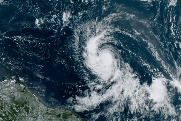
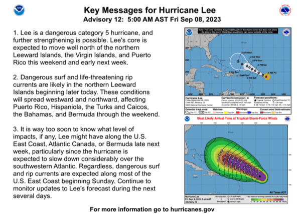
Lee has strengthened to a Category 5 Hurricane with maximum sustained wind speed of 165 mph, and further strengthening is possible. The National Hurricane Center expects the core to move well north of the Virgin Islands this weekend and early next week.
Thursday, September 7th
This is the latest information we have as of Thursday, September 7th, but we will continue to update you over the next few days as things progress. We recommend that if you are currently in the Virgin Islands or are traveling there over the next week, you monitor the storm daily as the track and intensity is still uncertain. You can sign up for weather alerts on the Virgin Islands Territorial Emergency Management Agency website.
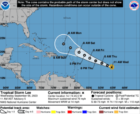
To give you an idea of just how rapidly it has been intensifying, on Wednesday morning the storm’s winds were blowing around 45 mph. On Thursday morning at 5am the storm had winds of 80 mph. They are projected by the NHC to increase to 145 mph by Sunday.
At this time the storm is expected to move on a path north of the Virgin Islands, slowly growing in size as it moves. However, a slight change in direction as things progress can make a huge difference in terms of the overall impact on us. Even if it stays on the same path north of the Virgin Islands, we should expect heavy wind and rain.
If the storm threatens the US Virgin Islands, the National Weather Service will issue a storm or hurricane watch 48 hours before, and a warning 36 hours before the arrival of storm or hurricane winds.
In anticipation of the potential threat, the Public Works Department and the VI Fire and Emergency Medical Services will provide six sandbags per household. Distribution would start Thursday at centers across St. Croix, St. Thomas, and St. John, with residents needing to bring a shovel and fill their bags.
Hurricane Lee is expected to be a Category 4 Hurricane by Saturday and will remain that way through Monday and the foreseeable future. Category 4 is the second most extreme class for a hurricane. With a Category 4 Hurricane you can expect high winds anywhere from 130-156 mph, lots of rain fall anywhere form 6-12 inches, and lots of debris being blown around. With conditions this extreme some of the things to be prepared for are, power outages, flooding, and damages to homes, stores and cars.
After this weekend it is expected to turn to the north, missing the mainland USA and traveling off the east coast, being far enough away to have no major impacts on the mainland.
As things progress, we urge you to continue to stay up to date on the latest and prepared. You can learn more about preparing for hurricanes on the Virgin Islands Territorial Emergency Management Agency website.