Well folks, we have great news to share with you today! But before I begin, I need to admit that I am little late to the party on this one. But nevertheless, this is great news to share with you!
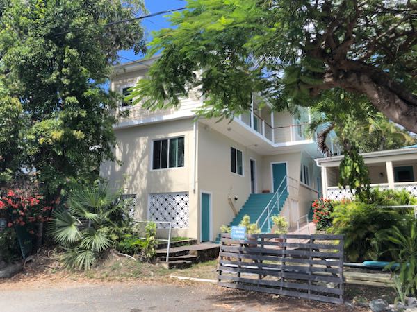
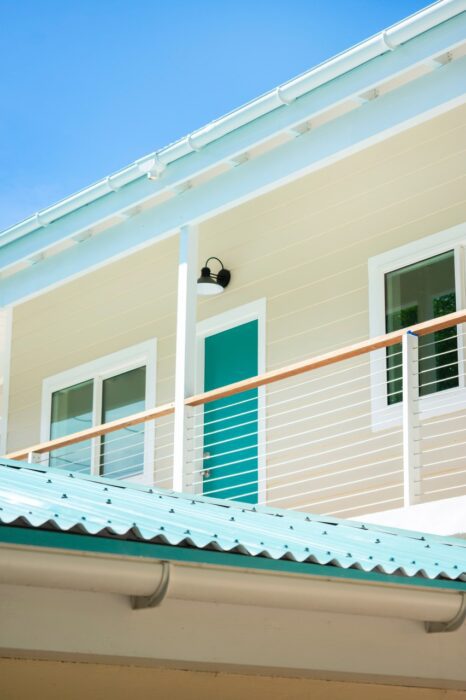
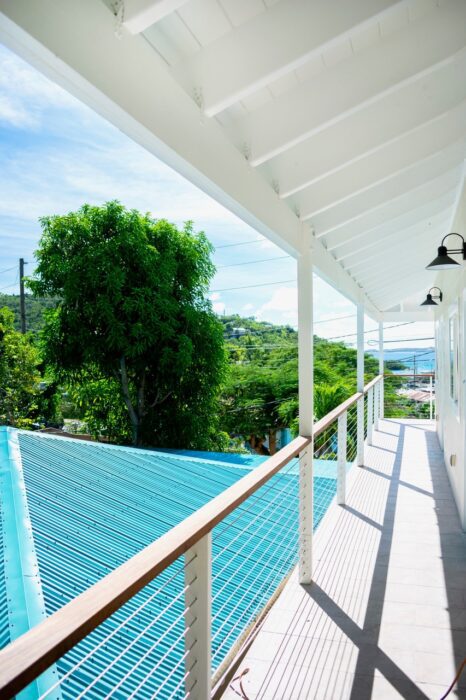
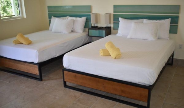
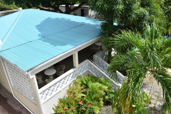
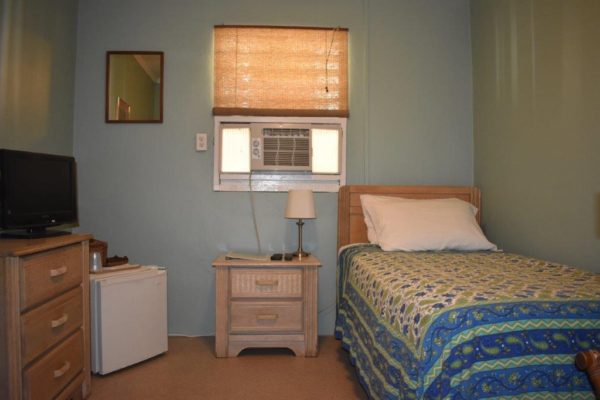
The Inn at Tamarind Court sustained tremendous damage during the 2017 hurricanes. After more than two years of remodeling, the Tamarind reopened its standard rooms to guests back in February, and the place looks great!
For those of you who are not familiar with the Tamarind, it’s an affordable spot that’s located just five minutes from the ferry dock in Cruz Bay. Rates start at $81 a night in low season and at $90 a night during high season … you can’t beat that, folks!
The Tamarind currently has 14 rooms that will be available once the Governor lifts the current accommodations ban. (As you likely have read, villas, hotels, inns, etc. cannot accept new guests though April 24.)
The Tamarind has eight standard rooms that were completely rebuilt following the storms. Of those, five have a queen bed and a private bath; two have two twin beds and a private bath; and one has two queen beds and a private bath. It also has six economy/single rooms that were renovated following the storms. This is a dorm-style building with two shared bathrooms. Each of the six rooms has one twin bed.
All rooms have cable, wifi, USB ports, ceiling fans, mini fridges and air conditioning.
Check out a few pics:
Upstairs exteriorUpstairs walkwayTwo queens roomThe Tamarind’s dorm-style building.A single room
Looks nice, doesn’t it?
There are eight additional rooms that are still under construction. Discounted rates are being offered while construction is ongoing.
Work continues on the Tamarind’s onsite restaurants. They hope to have that open by next season (mid to late fall), if not sooner.
St. Johnopoly is available and shipping daily. It’s about to sell out, so please get yours today!
St. Johnopoly is just like the traditional Monopoly game, but it is completely customized for St. John. If you would like a bit of St. John to arrive at your doorstep, order yours at www.newsofstjohn.com/stjohnopoly
Want to get News of St. John updates emailed directly to you? Please go to www.newsofstjohn.com/signup to sign up.
For the latest updates on COVID-19 and how it relates to St. John, please visit www.newsofstjohn.com/virus
We received an email the other day asking why we haven’t provided a COVID-19 update in roughly a week. Well sometimes no news is good news. There aren’t too many new changes to report. Here is what’s currently happening:
As of today, April 15, there have been two confirmed COVID-19 cases on St. John. There have been 51 confirmed cases in the US Virgin Islands, which includes St. John, St. Thomas and St. Croix. As of today, 417 people have been tested territory-wide.
The beaches remain closed through April 20. All trails are currently closed.
Accommodations including hotels, villas, Airbnbs, etc. cannot accept new guests through April 24.
There is a declared State of Emergency and a Stay at Home order that continues through April 30.
It is possible that some of these restrictions may be extended. If that happens, we will let you know.
Many of you have emailed me asking about upcoming trips, asking whether or not you think you can visit. Truthfully, I do not have an answer. All I can say is to listen to the advice of our Governor and the federal government’s advice pertaining to travel.
People have asked about seasonal closings. As many of you know, a fair amount of our restaurants close during hurricane season. Some close for a few weeks; some close for a few months. To my knowledge, none of the restaurants have made a decision regarding their seasonal closures yet. When those decisions are made, we will let you know.
Want to receive updates regarding COVID-19 cases in the US Virgin Island and other pertinent information? Just text COVID19USVI to 888777.
You can also visit our government’s website at www.vi.gov for the latest information on COVID-19.
Our Governor holds press conferences live on Facebook several times a week. He also holds question and answer sessions. Please visit www.facebook.com/GovernmentHouseUSVI for more information.
We’re pretty much all in a holding pattern right now. I want you all to visit again, but when the time is right. I look forward to showing many of you the island during one of my island tours. I’ve got some free time lately, so I’ve been working to rebrand my island tour business. I am excited to show you all the results! 🙂
In the meantime, please keep reading and keep loving this little island of ours! Stay safe and healthy everyone!
Tag: USVI COVID-19
St. Johnopoly is available and shipping daily. It’s about to sell out, so please get yours today!
St. Johnopoly is just like the traditional Monopoly game, but it is completely customized for St. John. If you would like a bit of St. John to arrive at your doorstep, order yours at www.newsofstjohn.com/stjohnopoly
Want to get News of St. John updates emailed directly to you? Please go to www.newsofstjohn.com/signup to sign up.
For the latest updates on COVID-19 and how it relates to St. John, please visit www.newsofstjohn.com/virus
Hello everyone, and happy Tuesday! Who needs a few minutes of zen in their lives today? I know I do!
Today’s Virtual Vacation is taking us up North Shore Road to each of the four overlooks – Cruz Bay, Caneel Bay, Trunk Bay and of course Maho and Francis Bays. It’s three minutes and 15 seconds of pure bliss. Enjoy!
Tag: North Shore overlooks
St. Johnopoly is available and shipping daily. We have a very limited quantity left. so please order yours today. It’s just like the traditional Monopoly game, but it is completely customized for St. John. If you would like a bit of St. John to arrive at your doorstep, order yours at www.newsofstjohn.com/stjohnopoly
Want to get News of St. John updates emailed directly to you? Please go to www.newsofstjohn.com/signup to sign up.
For the latest updates on COVID-19 and how it relates to St. John, please visit www.newsofstjohn.com/virus
Hello everyone, and happy Monday! I hope you all had a wonderful holiday this year! Over the last few days, we showed you how to drive the streets of St. John and how to look up public property records. Well today, we’re going to tell you how to find information on the boats that are in the bays surrounding St. John.
I’m sure you’ve been sitting on a beach and saw a beautiful boat out in the bay and wanted to know more about it. Or perhaps you were watching one of St. John’s many webcams and saw a cool boat pass by. Well it’s pretty simple to get information on these boats.
The first thing you need to do is visit www.marinetraffic.com or download the Marine Traffic app. (There may be a small fee associated with the download.) Then choose which part in the world you want to learn more about.
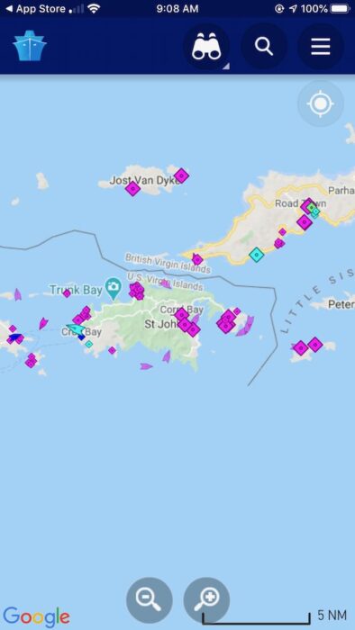
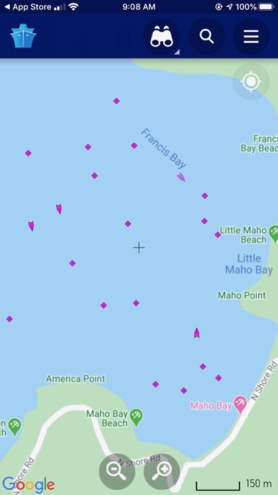
Obviously today we’re talking about St. John. I first zoomed into the US Virgin Islands. Next I zoomed into the area near Maho and Francis Bays. The following screenshots were taken from the app, not the website:
The colored shapes are vessels that are currently around the Virgin Islands.These are the vessels that are currently in the Maho and Francis area.
You will see in the first screenshot that there are a few different colors. The magenta colors indicate a pleasure vessel. Dark blue shapes are typically ferries, barges and cruise ships. Red colors usually show tankers. Light blue shows tugboats. Green usually shows cargo ships. All of these vessels are using transponders.
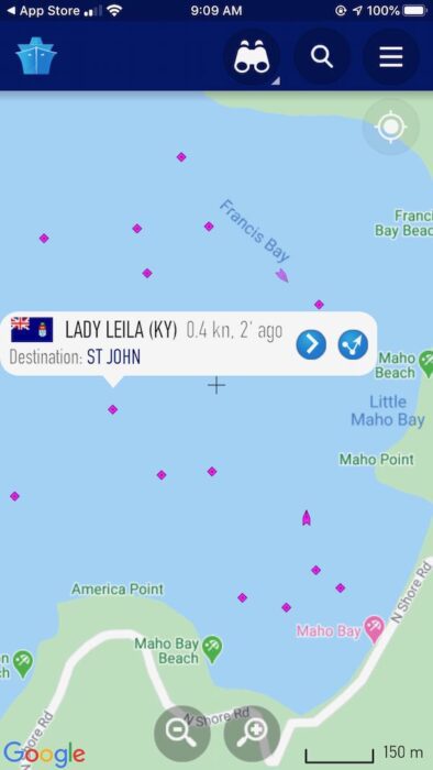
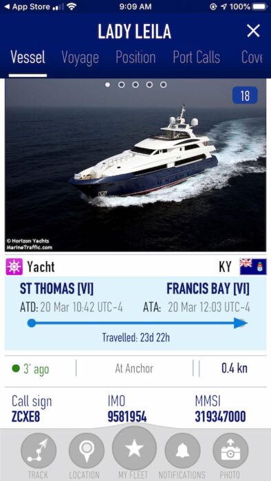
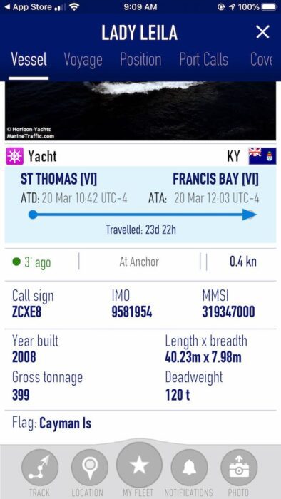
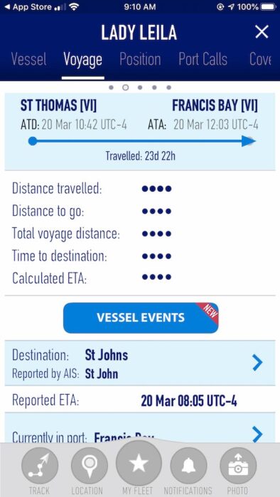
When you are interested in a vessel, simply click on it. Information including the ship’s name, call sign, type, size and port calls will pop up. Here is an example of the Lady Leila, which has been anchored near Maho and Francis for several weeks.
Once you find a name, you can do a quick Google search to learn more. The Lady Leila, for example, is a charter boat.
Pretty neat, right? Just another way for you all to pass the time during this pandemic.
Have a great day, safe safe and be kind! We’re all in this together, folks! 🙂
Tag: Boat near St. John
St. Johnopoly is available and shipping daily. We have a very limited quantity left. so please order yours today. It’s just like the traditional Monopoly game, but it is completely customized for St. John. If you would like a bit of St. John to arrive at your doorstep, order yours at www.newsofstjohn.com/stjohnopoly
Want to get News of St. John updates emailed directly to you? Please go to www.newsofstjohn.com/signup to sign up.
For the latest updates on COVID-19 and how it relates to St. John, please visit www.newsofstjohn.com/virus
We originally printed this story in 2017. We thought it was good enough to share again. Enjoy!
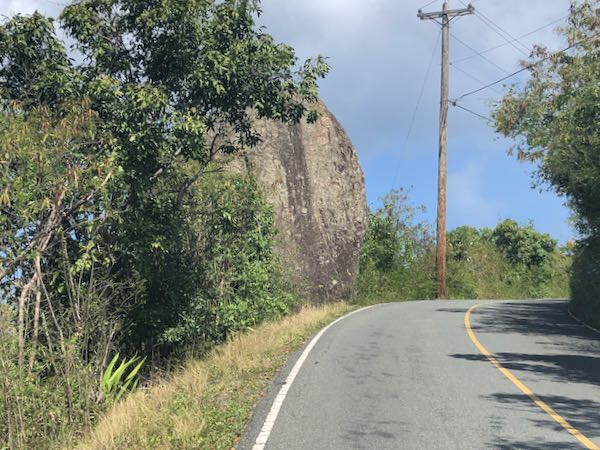
How may of you have driven past the large boulder on North Shore Road between Gibney and Oppenheimer beaches and Peace Hill and wondered what its backstory was? At least a few of you, I’m sure! Well this Easter weekend we’d like to share with you the story of Easter Rock.
Legend has it that every year on Easter morning, Easter Rock makes its way down to Hawksnest Bay where it takes a drink of water and then rolls back up to its perch on North Shore Road. This all happens before the sun rises over the hill, according to the legend, so no one is around to actually witness it. And even during the driest of droughts, Easter Rock will always wet on Easter morning, according to the legend.
Legend aside, are you curious as to how Easter Rock came to be? Well here’s its geological backstory straight from See St. John:
Although geologists have not yet succeeded in explaining Easter Rock’s propensity to go down to the sea on Easter Sunday for a drink of water, they can tell us about the origin of this massive boulder, which is the only one of its kind in the valley.
The outer crust of the Earth consists of large masses of slowly moving rock called tectonic plates. About 100 million years ago, one of these plates, called the North American plate, which was moving towards the west, encountered another tectonic plate called the Caribbean plate, which was moving in the same direction.
Life in the Caribbean has long been classified as slower moving than in the fast-paced world of continental America. This phenomenon apparently has a historical and geological foundation because a significant factor in the creation of many of the Caribbean islands, including St. John, is the fact that the Caribbean plate happened to be moving at a slower pace than its continental counterpart.
Consequently, when the North American plate overtook the slower moving Caribbean plate, the American plate, being denser and heavier, slid under the Caribbean plate and pushed it up. The friction from the two giant masses of solid rock grinding against one another produced a heat so intense that it melted some of the rock between the two plates. The fiery, liquefied rock, called magma, built up in enclosed pockets, called magma chambers, and exerted an ever-increasing pressure on the surrounding rock. When that pressure became so great that it could not be contained any longer, the magma broke through its rocky chamber and spewed forth violently into the ocean. This event is called a volcano.
Normally, when super-hot magma comes in contact with cold ocean water, the magma explodes and is dispersed over a great area. In this case, however, the eruption occurred at a depth of 15,000 feet, or nearly three miles, below the surface of the ocean. At this great depth the water pressure is nearly 7,000 pounds per square inch, a pressure that was sufficient to keep the magma from exploding on contact with water and instead causing it to be deposited on the ocean floor in giant solid sheets.
Coinciding with this volcanic activity and the laying down of rock, the action of the American plate sliding under the Caribbean plate caused the latter to bulge at the edges. The combination of these events resulted in the beginnings of a mountain range that was to become the islands of the Greater Antilles. This process of volcanic activity and uplifting continued for millions of years and caused the newly formed mountains to move closer to the surface.
It was during the next period of St. John’s development that Easter Rock was born. A series of volcanoes erupted in the area of what is today called Pillsbury Sound. This time the water was relatively shallow and the volcanoes erupted explosively. The shower of rocks, solidified volcanic ash, and molten lava added substance and height to the older solid sheets of rock and, in conjunction with the continued uplifting of the area, eventually brought parts of the rocky underwater mass above sea level to form islands.
The awesome power of these violent eruptions also served to break off huge chunks of the older rock, heaving them into the air. One of these massive fragments ended up just above what was to become Hawksnest Bay. That majestic boulder, now known as Easter Rock, not only goes down to the sea every Easter for a drink of water, but also serves as an enduring reminder of the fiery beginnings of the island of St. John.
Well there you have it … news you can use today!
I hope you all have a wonderful Easter holiday. Stay safe, be kind and wash those hands. 🙂
St. Johnopoly is available and shipping daily. We have a very limited quantity left. so please order yours today. It’s just like the traditional Monopoly game, but it is completely customized for St. John. If you would like a bit of St. John to arrive at your doorstep, order yours at www.newsofstjohn.com/stjohnopoly
Want to get News of St. John updates emailed directly to you? Please go to www.newsofstjohn.com/signup to sign up.
For the latest updates on COVID-19 and how it relates to St. John, please visit www.newsofstjohn.com/virus
When you’re driving down the road and you see an incredible villa, part of you (or at least me) wants to know who owns the property. Or perhaps you’re doing a little villa shopping and you’re curious who owns a parcel or even the adjoining land. Well, you can find out that information pretty easily. And today, we’re going to tell you how.
The way it works is simple: First, visit https://usvi.mapgeo.io. There you’ll find two main ways to search for a property record. First, you can zoom in to either St. John, St. Thomas or St. Croix. Once you zoom in to a particular island, the property lines will pop up. Click on the parcel of interest to you, and you will see the owner’s information.
You can also look up property information by address, property owner or property id. For example, you can type in Peter Bay if you want to pull up the property records in that area.
This system was launched in 2014. At the time, the then-lieutenant governor stated: “Our goal remains to remove the mystery associated with property records of this territory … Recent updates to the GIS viewer, which provides property data and the territory’s most current aerial photography, now gives users access to a wealth of property information, to include zoning, flood zone, soil and topography data and street addresses.”
Please note: The information is not updated in realtime.
Just like the maps we told you about yesterday, this site is great for passing lots of time. Enjoy everyone! Have a wonderful weekend!
Tags: St. John property records, USVI property records
St. Johnopoly is available and shipping daily. It’s just like the traditional Monopoly game, but it is completely customized for St. John. If you would like a bit of St. John to arrive at your doorstep, order yours at www.newsofstjohn.com/stjohnopoly
Want to get News of St. John updates emailed directly to you? Please go to www.newsofstjohn.com/signup to sign up.
For the latest updates on COVID-19 and how it relates to St. John, please visit www.newsofstjohn.com/virus
Hello everyone, and happy Friday! I know how much you’re all missing St. John. Unfortunately you cannot physically visit the island today, but you can visit it virtually … all while taking a little journey down memory lane! And I know many of you, like me, are spending countless hours at home these days, so this is a great way to pass the time.
Today we want to talk to you about maps – Apple and Google maps specifically. Both offer the opportunity to take virtual trips around the island. With Apple, you can check out the island in 3D. And on Google, you can actually drive down the street. The only caveat is that most, if not all, of the images are from our pre-storm world.
Let’s start with Apple Maps. Grab your iPhone or iPad, and open the Maps application. Then either find St. John on the map, or type in Cruz Bay. Once you have St. John on your screen, hit the little “i” icon on the top right. Then click Satellite. You will see 2D on the top right of the screen. Click that and 3D will appear. You’ll immediately see a change on your screen.
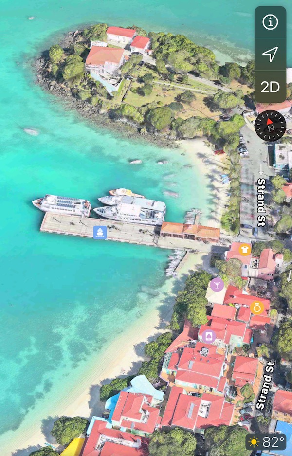
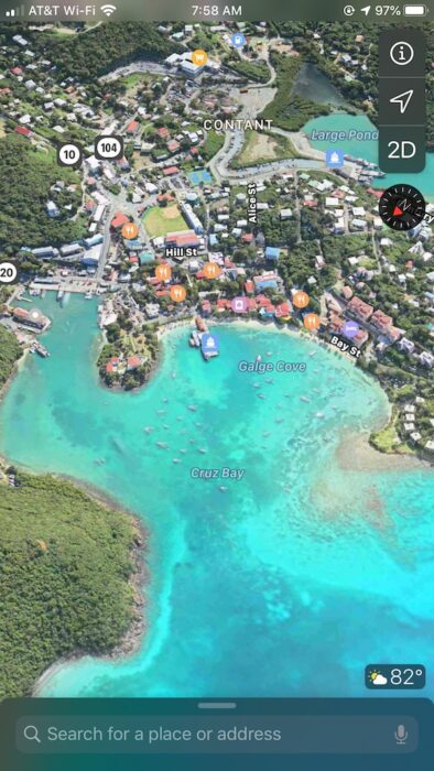
From there, you simply explore. You can zoom in pretty far and also spin the map around. Press your fingers together and apart to see different perspectives. Here’s a shot of Cruz Bay:
Cruz Bay
Want to know what the Westin looked like before the storms? Well here is an image of that:
The Westin
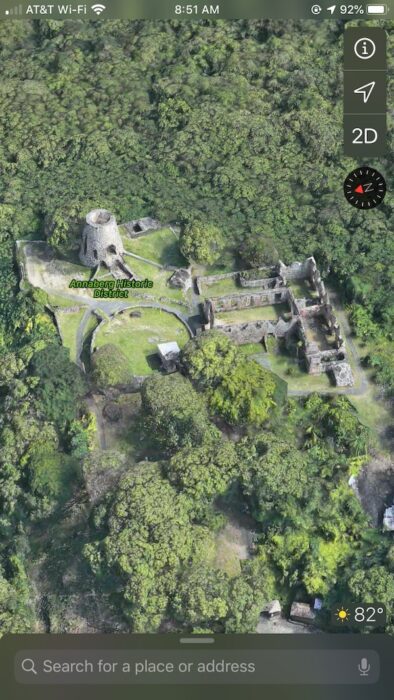
Check out the Annaberg ruins:
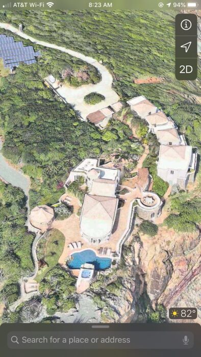
How about Marea, the stunning, sprawling compound located at the end of Ditliff Point? Well here is an image of that:
Marea on Ditliff Point
As you can see from the images above, there is so much to look at.
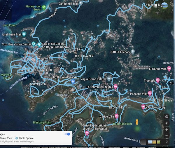
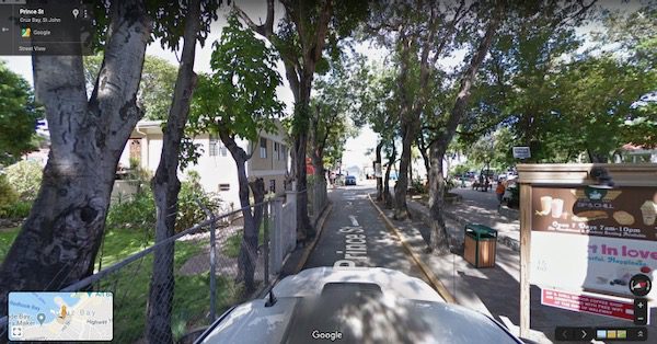
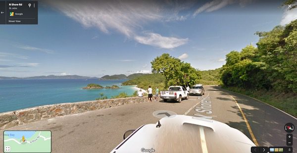
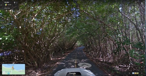
Now let’s talk about Google Maps. This is accessible to everyone regardless of what type of device you have. Pull up Google Maps and then click Satellite in the lower lefthand side of your screen. You will then see a small yellow “man” appear in the bottom right corner. You can drag and drop him to most areas on the map. The real that will work have a blue line on them. Once you drop the “man,” you will be in Street View. You can then literally drive down the streets of St. John simply by clicking the arrows on the screen.
Click the yellow man, then drag and drop him to a place on the screen.
Here we are driving down the street toward the ferry dock:
Trunk Bay overlook anyone?
And one of my favorites, the road to Annaberg when the trees formed a beautiful tunnel…
Again, all of these images were taken before the storms. I did see a Google Maps car on the island several months back, so the images should be updated at some point.
How fun is this?! It’s like being on St. John when you are physically unable to. 🙂
That’s all we have for you today, folks. Have a great day! Stay safe & stay inside if you’ve been asked to. The more we work together on this, the quicker our lives can return to normal … and the quicker I can see you all again! I miss you all!
St. Johnopoly is available and shipping daily. It’s just like the traditional Monopoly game, but it is completely customized for St. John. If you would like a bit of St. John to arrive at your doorstep, order yours at www.newsofstjohn.com/stjohnopoly
Want to get News of St. John updates emailed directly to you? Please go to www.newsofstjohn.com/signup to sign up.
For the latest updates on COVID-19 and how it relates to St. John, please visit www.newsofstjohn.com/virus
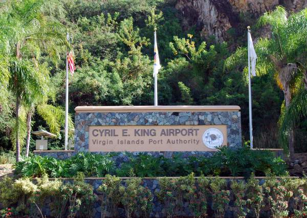
The Cyril E. King airport is located on St. Thomas. It is the airport you need to fly into when visiting St. John.
Over the past two days, we’ve talked a great deal about flights in and out of the Cyril E. King airport on St. Thomas. But did you ever wonder who the airport’s namesake was?
The Virgin Islands Port Authority shared some details about Mr. King yesterday, the day that would have been his 99th birthday, and we found it to be very interesting. So we thought we would share it all with you today. The following was originally published by the Virgin Islands Port Authority:
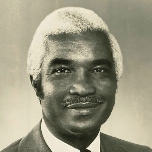
Mr. Cyril E. King
Cyril Emmanuel King was born in St. Croix on April 7, 1921. King served with the U.S. Army during World War II, and in 1951, he received a bachelor’s degree in public administration from American University.
In 1949, he was appointed as an aide to Senator Hubert Humphrey, becoming the first black man to serve in the office of a U.S. senator. In 1957, the Organic Act Committee of the Virgin Islands legislature voted to appoint King as its deputy in Washington, D.C., to secure congressional action to amend the Organic Act, the “constitution” of the Virgin Islands.
In 1961, President John F. Kennedy appointed King as the U.S. Virgin Islands’ government secretary – a post equivalent to the present position of lieutenant governor. King was Acting Governor of the Virgin Islands for six months in 1969 and was elected to the Virgin Islands Senate in 1972. In 1974 he became the territory’s second elected governor for a four-year term. He died in office on January 2, 1978.
Construction of a new airport terminal on St. Thomas began two years after his death. King was instrumental during his term as governor in helping the territory obtain federal funding to build the new terminal and the critical expansion of its too-short runway. On October 3, 1984, the former Harry S. Truman Airport was renamed in honor of the late Governor King to memorialize his service and dedication to the people of the USVI – per Act 4993. The terminal was completed in October 1990. The runway was extended from 4,200 feet to its present 7,000 feet length in 1992. The airport features one of the largest deep-water, dredged runways in the Caribbean.
The Virgin Islands Port Authority received funding from the U.S. Department of Commerce-Economic Development Administration in 2019 to begin phase one of a massive upgrade and modernization of the airport terminal. Phase one of the project, which entails the construction of a $20 million, 700-parking space garage and transportation center, is slated to begin this year.
Isn’t that an interesting story? If there is something you are interested in learning more about with regard to St. John, please send us an email at [email protected]. In the meantime, have a great day everyone! Stay safe, and wash those hands! 🙂
St. Johnopoly is available and shipping daily. It’s just like the traditional Monopoly game, but it is completely customized for St. John. If you would like a bit of St. John to arrive at your doorstep, order yours at www.newsofstjohn.com/stjohnopoly
Want to get News of St. John updates emailed directly to you? Please go to www.newsofstjohn.com/signup to sign up.
For the latest updates on COVID-19 and how it relates to St. John, please visit www.newsofstjohn.com/virus
The Governor announced Monday that all beaches in the US Virgin Islands will be closed through April 20 in an effort to further enforce social distancing. The release went on to say:
“Persons known to have the virus who willfully violate the directives as determined by the Health commissioner can be criminally charged under Title 14 of the V.I. Code, according to the Attorney General.
“Title 14, subsection 886 states “[w]however willfully exposes himself or another afflicted with any contagious or infectious disease in any public place or thoroughfare… shall be fined not more than $200 or imprisoned not more than 1 year, or both.”
The Virgin Islands National Park followed up the Governor’s announcement with a release of its own that stated all trails and parking lots in the Virgin Islands National Park will be closed too. All park waters remain open. “Mariners using park moorings and anchorage areas can expect further guidance and safety requirements later this week,” the release said.
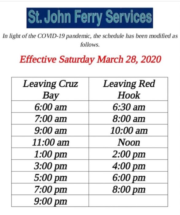
The ferries and barges have altered their schedules as a result of the COVID-19 pandemic.
Here is the current passenger ferry schedule:
The current passenger ferry schedule between St. John & St. Thomas.
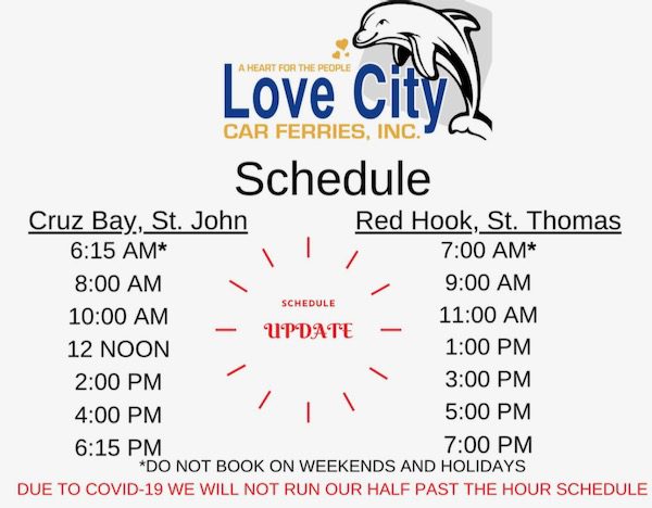
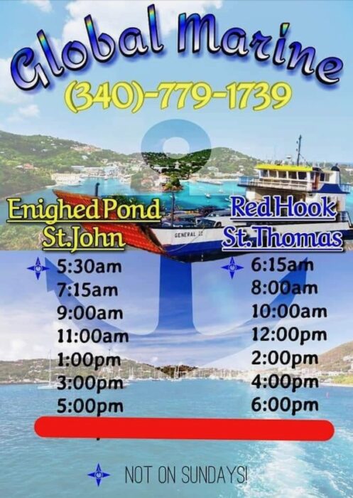
Three barge companies provide service between St. John and St. Thomas – Love City Car Ferries, Global Marine and Big Red Barge Co. Here are their updated schedules:
The current schedule for Love City Car Ferries (Grand Vic)The current schedule for Global Marine (General II)The current schedule for Big Red Barge
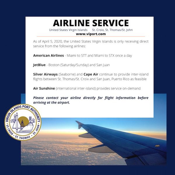
The Virgin Islands Port Authority released the following information yesterday regarding flights to the Territory:
The Governor announced that all incoming passengers are being screened for COVID-19.
And to reiterate, the US Virgin Islands are currently under a State of Emergency and will be through April 30. All non-essential businesses are closed through April 30. Hotels, villas, Airbnbs, etc. are not allowed to accept new checkins through April 24. If any of these dates get extended, we will be sure to let you know.
St. Johnopoly is available and shipping daily. It’s just like the traditional Monopoly game, but it is completely customized for St. John. If you would like a bit of St. John to arrive at your doorstep, order yours at www.newsofstjohn.com/stjohnopoly
Want to get News of St. John updates emailed directly to you? Please go to www.newsofstjohn.com/signup to sign up.
Hello everyone, and happy Tuesday! Who wants to take a virtual vacation today??! You know you do!
Today we’re bringing you over to Jumbie, one of our favorite beaches on St. John’s north shore. It also happens to be a favorite of Dalton’s, my 21-month-old son. There are only a handful of parking spots at Jumbie, so it never gets too crowded. It does include a short walk in the woods – 320 feet to be exact – and it’s completely worth it. Today’s video is under three minutes long. Enjoy!
The Governor announced Monday afternoon (April 6, 2020) that all beaches in the US Virgin Islands will be closed through April 20. This video was filmed last week, prior to the Governor’s announcement.
Tag: St. John Virtual Vacation
St. Johnopoly, St. John’s only board game, is available and is still shipping. Our next shipment goes out today. If you would like a bit of St. John to arrive at your doorstep, you can order yours at www.newsofstjohn.com/stjohnopoly
Want to get News of St. John updates emailed directly to you? Please go to www.newsofstjohn.com/signup to sign up.