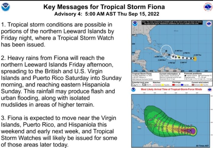
Hello All! Remember earlier this week when I told you that everything looked okay out there in the Atlantic Basin but that we shouldn’t let our guards down because it IS still peak hurricane season? Well, as we all know, things can change pretty quickly in Mother Nature’s planner and Tropical Storm Fiona is now headed towards the Caribbean with the first watches issued at 8AM to Saba, St. Marteen, Antigua, Barbuda, St. Kitts, Nevis, Montserrat and Anguilla. So, I wanted to take a quick moment this morning to alert any of you who may have travel plans into or out of the territory this weekend of the possible impact of Tropical Storm Fiona.
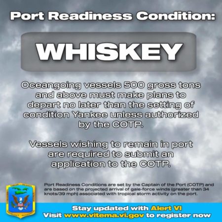
Now, in the words of Dan Boyd, “NO FREAKING OUT!” The likelihood that this storm will have more impact than heavy rains and high wind speeds on St. John is low. But you never know with Mother Nature, and it is ALWAYS best to prepare for the worst and hope for the best! And the likelihood IS high that travel plans will need to be adjusted if you are planning to utilize the flight plans in and out of the St. Thomas airport between Friday afternoon and Sunday morning as the Virgin Islands Territorial Emergency Management Agency (VITEMA) issued Port Condition WHISKEY yesterday afternoon. The port condition WHISKEY (issued when weather advisories indicate sustained gale force winds (39-54 mph/34-47 knots) from a tropical or hurricane force storm are predicted to make landfall at the port within 72 hours) is scheduled to begin at noon today.

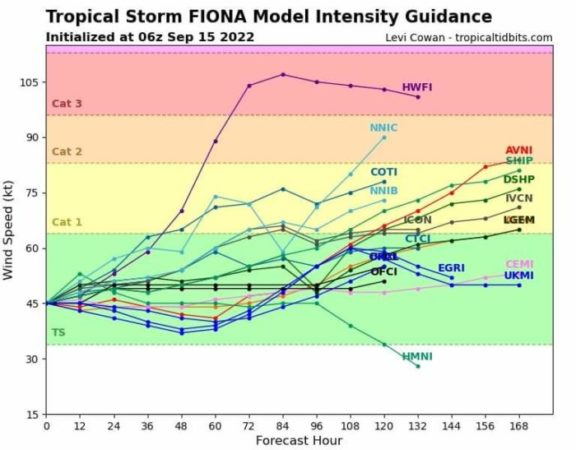
Now, there are several different models that give varying predictions of Fiona’s path. Some with the eye moving directly over St. John and the BVI and others with the eye moving to the south of us. But, regardless, if you are on island right now, or planning to be there this weekend, you can plan to see heavy rain from Friday evening through Sunday morning and winds in excess of 30 miles per hour. The predictions, at this point, are kind of all over the place about the strengthening and formation of Fiona into anything more than a Tropical Storm.

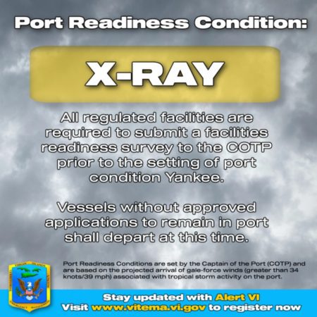
BUT it is my estimation that seaports (ferries) will be closed beginning at some point tomorrow. Port Condition Yankee will likely go into effect, closing the ports – “Condition YANKEE is set when weather advisories indicate that sustained gale force winds (39–54 mph/34–47 knots) from a tropical or hurricane force storm are predicted to make landfall at the port within 24 hours.” It is also my estimation that at least Saturday’s scheduled flights will be mostly cancelled if the airport does remain open through the weekend.
Now, all of this could change for the better or for the worse over the next 24 hours. Heck, it could end up being an absolutely beautiful weekend! But if you have an incoming or outgoing flight at STT between late Friday and early Sunday, you should likely call the airline ahead of time to find out what your contingency plan could be.

If you are on St. John right now and are scheduled to fly on Saturday, you could do one of the following to be better prepared for a possible disruption in travel plans:
- Check with your current accommodations about extending your stay if you get stuck for an extra day or two.
- Look around for availability at a different lodging option on St. Thomas or St. John for a few extra nights. Contact the host or manager directly to find out about booking a tentative night or two without cancellation penalties if the ports do not close and you are able to make your scheduled flight.
- Either way you go on the lodging options, ABSOLUTELY contact the airline ahead of time (today) to find out what your options are if flights are canceled this weekend. It is ALWAYS best to be the person who reaches out in advance rather than be one of the masses after the travel hiccup has occurred.
If you are not on St. John currently but have plans to arrive on St. Thomas this weekend, call the airline now to find out what your options are for arriving early next week. Also contact your accommodations and any activities you have set for your upcoming trip to find out what your options are for cancelling or rescheduling. Remember all that nonsense I was talking about the importance of travel insurance this time of year? Now is the time 🙂
As I write this, another update just came in from St. John VI Weather stating the following:
Tropical Storm Fiona is forecast to pass over the Island of St Croix around mid-day Saturday.Fiona is not forecast to intensify due to upper-level West/Northwest wind shear and the dry air in front of TS Fiona.As I have stated before, the only predictability of Tropical Cyclone Systems is their unpredictability! Please stay vigilant and stay safe!

Also, as I type this, VITEMA has issued the following update to the Port Condition:
At 0800 local time, Port Readiness Condition X-RAY will be set for the Ports of Puerto Rico and the U.S. Virgin Islands due to the potential impacts of Tropical Depression 07L. Anticipate readiness condition YANKEE tomorrow at 0800 and ZULU on Friday at 2000 for all Ports.
So, all USVI ports will be closed tomorrow, Friday evening at 8PM.

Remember, everything could be absolutely fine this weekend. But the watches issued for our sister islands to the East this morning could pass to the USVI very soon and it is ALWAYS better to be prepared than not as the situation is rapidly evolving. Please reach out directly if you have any questions in regard to this weekend as I am very happy to assist all of you with moral support or information exchange. Stay safe everyone and DO NOT FREAK OUT! But do keep an eye on the weather and port conditions for this weekend via the following links.
- VITEMA’s Facebook Page– Port conditions and storm updates from the USVI
- Virgin Islands Port Authority– Airport and seaport conditions
- St. John VI Weather– On the ground and up-to-date reports on weather in the area straight from Lovango Cay
- Mike’s Weather Page– A bird’s eye view of all models for all tropical disruptions
- Windy– Real time predictions in an easy to understand and visually pleasing format from three different weather models.


Thank you Hilary. You are always soooo helpful
Hi Hilary,
Thanks for another informative well written article. Hopefully the storm doesn’t strengthen too much more The St. John Weather page is a private Facebook group and not everyone uses facebook.
I use Weather.vi which is run by someone who lives on STJ and has installed a weather station at the house, along with a webcam, and gives a plethora of other forecasts on that page as well. It is laid out well and is easy to read, and doesn’t require Facebook to look at it.
Thank you
Hi Hillary!
Just had to check in. Talked with your mom & dad tonight at your mom’s 50th class reunion. What a hoot! This is your 6th grade teacher Mrs. Cottis. Hello to you from Uhrichsville, Ohio!
Stay safe & keep writing! How wonderful!❤️