Good Morning All! We have talked a lot over the past few months about what to expect while traveling to St. John during hurricane season. Well, as of Monday evening, a tropical storm warning was called into effect for the USVI and Puerto Rico. A weather disturbance, currently over the Eastern Caribbean, tracks south of St. Croix and could bring a decent amount of wind and rain to the territory later today. But, “Don’t Freak Out!” Here’s a bit about what you might see during these tropical storm conditions and some pointers on what to expect and how to prepare out for rough weather while visiting the territory during the peak hurricane season months of August-October.
First, a bit about this particular disturbance. The National Hurricane Center issued warnings and watches throughout the Caribbean on Potential Tropical Cyclone Six with a high possibility of formation into what could be the next named storm of the 2021 Hurricane Season. Ladies and Gentlemen, meet “potential” Fred. The storm is currently south of St. Kitts and Nevis and is tracking south of St. Croix with winds predicted between 35-45MPH.

If it stays on track, the storm will likely bring squall like conditions to the seas surrounding the territory as well as wind and rain through the later part of today and stretching into the night.
So, what does all of this weather jargon mean and what does this “Potential Fred” mean for your next 24-36 hours on island? And, how can you best be prepared for these inevitable conditions while vacationing in the Caribbean during this time of year?
When I first moved to St. John, one of the most frustrating things for me was that I didn’t understand what I was looking at with these weather reports and alerts. My inquiring mind dove into figuring it out and I’ve got a little Hurricane 101 for you here to save you the trouble with Google as advisories roll in.

The difference between a watch and a warning, I think, is a good place to start. Essentially, according to NOAA.gov, a warning is issued when tropical storm conditions are expected and a watch means that conditions are possible. Hurricane warnings are generally issued when the imminent threat of weather is just 36 hours out, while a watch gives a bit more of a proper heads up at 48 hours out.
Ok, so, a tropical storm (this is not yet a hurricane…it’s technically still a depression. See below.) warning for the USVI and Puerto Rico means that tropical storm like conditions are expected in the territory within 36 hours. Got it? Ok. Next, what is the difference between a disturbance, storm, cyclone, hurricane, etc?
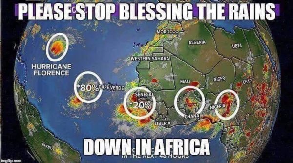
- Tropical Wave– Tropical Waves in the Atlantic develop from low pressure disturbances in Africa and are carried into the Atlantic Basin by the West moving trade winds. You’ve heard the song right? Bless the waves down in Africa? Well, have you seen the meme? 🙂 Basically, when these waves get stuck in their tracks or fizzle out, there is no escalation to tropical storm or hurricane. Otherwise, these can lead to the formation of a Tropical Cyclone.

- Tropical Disturbance– This one is a bit more “organized” and originates in the tropics or sub-tropics. It is generally 100-300 miles in diameter and has maintained this profile for 24 hours or more.
- Tropical Cyclone– Develops over tropical and sometimes sub-tropical waters and has organized deep convection with a closed wind circulation about a well-defined center.
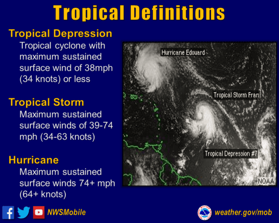
- Tropical Depression– This is about the time to start paying closer attention. A depression is defined as a tropical cyclone that carries sustained surface winds of 38 MPH or less. This is just about where we are right now with “Potential Fred” as predictions are calling for 35-40MPH winds once it hits the territory. But with a decent chance of formation, the National Hurricane Center is calling for a “Tropical Storm” Watch.
- Tropical Storm- A tropical cyclone with maximum sustained surface winds of 40-73MPH. This is the point at which a storm is “named.”
- Hurricane- Once a cyclone reaches sustained winds of 75MPH or greater, it is considered a hurricane. Hurricanes are categorized into 5 levels based on the Saffir-Simpson Wind Scale:
- Category 1- 74-95 MPH winds
- Category 2- 96-110 MPH winds
- Category 3- 111-129 MPH winds
- Category 4- 130-156 MPH winds
- Category 5- 157 MPH winds or higher

Ok, so now you know what you’re looking at with weather advisories. What can you potentially expect on St. John today through tomorrow?
Starting early this afternoon, the waves and winds will likely pick up a bit. We might see some bands of rain. Based on the current predictions, when I’m finished writing this, I’ll probably plan for a morning at the beach or a hike and then head to town for some lunch to see what the weather does. If it is holding steady, I’ll likely linger into early happy hour before heading back to my place to enjoy the sound of the wind and rain this evening. This particular system, if it stays on track, shouldn’t pose too much of a problem as far north as St. John, however, Hurricane Dorian was on a similar path in 2019 and took a hard right at St. Croix, hitting the northern USVI with Category 1 winds and rain. So, in cases like this, it is ALWAYS best to prepare for the worst and hope for the best!

I did run this article by a friend of mine who is my go to weather source for what’s happening around St. John. His words were….
Tropical Storms/Hurricanes can be very hard to predict, even with today’s technology. The only thing predictable about Tropical Storms/Hurricanes is their unpredictability! Be prepared and Stay Vigilant! – Dan Boyd, administrator of St. John VI Weather Facebook Page
Over the past two months, I have posted two different articles in regards to how to best prepare for vacationing in the Caribbean (St. John specific!) during peak hurricane season.
June 1, 2021 – Hurricane Season Begins Today!
July 5, 2021 – What you need to know about traveling during hurricane season
In the above posts, you’ll find some ways to be best prepared, the pros and cons of vacationing in a hurricane zone during the late summer and early fall, packing lists and what to expect on St. John during a storm. Oh, and one thing I mistakenly omitted from both of those…DOH!…Follow the USVI Port Authority Page on Facebook for info on scheduled port closures (that’s the ferry!) in the event of weather!
So, read up, follow along with the weather and enjoy your time in Love City while also keeping an eye on your surroundings!


I really like your informative articles – thank you so much.
Be prepared for power outages of unknown duration. Know what you will do.